
Maps for Mobile Devices
Q: Can I download your maps for use on my phone or tablet?
After many years of having to answer 'no', we are thrilled to now be able to answer YES. See our Maps for Mobile page for full info.
Q: Can I use the maps in areas without cell service?
Yes! As long as the map is downloaded in an area when you do have cell service (or better yet, WIFI), the maps will display and work in areas without cell service. Your phone or tablet's internal GPS enables showing your location on the map.
Q: Can I transfer my downloaded mobile maps onto my Lowrance chartplotter?
No, unfortunately not - the maps downloaded via the Avenza Maps app are a different file format that cannot be displayed on a Lowrance unit.
Q: I'm having trouble searching for AEM maps on Avenza - help!
Here's a couple of search tips, applicable once in the Store screen on the Avenza Maps app:
1. If you want to browse AEM's map offerings:
- Clear the default location from the 'Location' field when you enter the Store screen in Avenza, otherwise only a small area near your current location will be searched and results will be limited
- use "aem" or "angler's edge mapping" in the 'Keywords' field
- For a view of the search results on a map background, click the "map" view toggle from the list of results as shown below
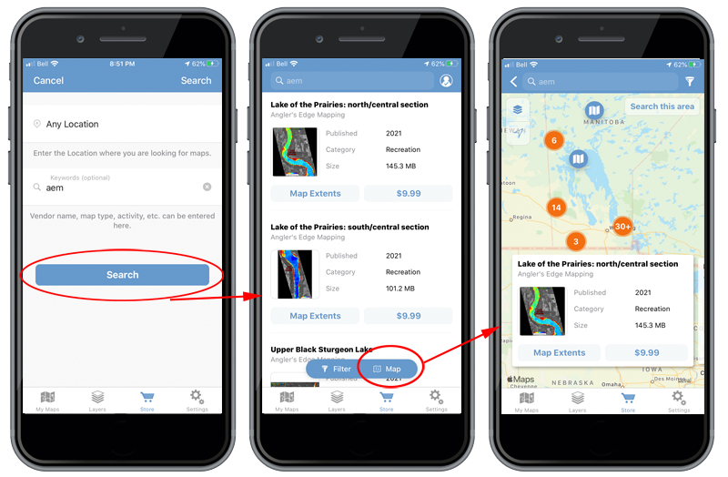
2. If you want to search for a specific lake:
- type in the water body name in the 'Location' field and choose a suitable location from the results, then type in "aem" or "angler's edge mapping" in the 'Keywords' field
Q: Can I download all your maps at once via Avenza?
No, our mobile maps are available for individual lake downloads only to allow flexibility. Users are free to download as many as they would like.
Upgrades
Q: I understand you're in the process of mapping more lakes. Do you offer an upgrade program?
Yes, we are in the process of releasing maps of many additional lakes. Our on-the-water surveys are conducted during the open-water season. Based on the data collected, we typically release some "ice-centric" content in late fall, and then more again the following spring. Upgrades are our way of offering existing AEM users access to the newest data without needing to buy a whole new chip. For example, if you purchase an 'Eastern Manitoba 2025' and we subsequently add more content to it later you have the option to upgrade the chip, or if you want you can also choose to upgrade to a Complete Catalog chip. Upgrade costs are influenced by the amount of new mapped content, plus a small processing fee associated with reprogramming the map card. For full details on the upgrade process, visit our upgrades page.
Q: My AEM chip is several years old - can I still upgrade it?
Yes! Any vintage of AEM chip is able to be upgraded. Upgrade cost is generally proportional to the amount of new content, so it will generally cost a bit more to upgrade older chips, but it will still be considerably cheaper than buying a whole new chip.
Q: I have a Lake Winnipeg chip, can I upgrade it to Complete Catalog?
Yes! Any of our 'area specific' chips - ie Whiteshell, Winnipeg River, Lake Winnipeg, Western MB, Eastern MB, Northwest Ontario, Northern MB, Saskatchewan - are able to be upgraded to a Complete Catalog chip. When ordering the upgrade online, you'll be able to select which chip you want to upgrade to, and Complete Catalog will be an option you can choose.
Compatibility
Q: I want to buy a Lowrance unit to run AEM maps - which do you recommend?
This is somewhat of a loaded question that depends on your budget among other things. We are huge advocates of Lowrance's Elite FS chartplotters and feel they offer the best value in chartplotters from any manufacturer. You'll spend a bit more on an Elite FS than you will on (for example) a Hook Reveal, but if your budget permits, you'll be much better off with an Elite FS. The touch screen interface makes them extremely user friendly, along with a very intuitive menu structure and great processing power which results in smooth rendering of AEM maps when panning/zooming or traveling at speed. They have full networking capability via both Ethernet & NMEA, have WIFI capability to enable quick and easy software updates as well as remote control via a phone or tablet (permitting extension of your display to a 2nd device that can be located elsewhere on the boat). There are certainly added capabilities that HDS Live units have above the Elite FS', but we still feel the Elite FS units pack the most value for the price.
p.s. the touch screens work fine in the cold. We've been using them on snowmobiles and ATV's for years for ice fishing applications.
Q: Do your Digital Maps work on Humminbird (or Garmin) chartplotters?
No, our Digital Maps are NOT compatible with Humminbird (or Garmin) chartplotters. They are only compatible with modern Lowrance (and Simrad) sonars - for a list of compatible models, please refer to the Digital Maps page. If you have a lot of money invested in non-compatible electronics, but are interested in using our maps, purchasing a small Lowrance unit only for chart display might be an attractive option. The Hook Reveal 5 is the unit we would currently recommend for the previously described situation.
Q: Which Lowrance units are compatible with AEM maps?
AEM digital maps are compatible with the following Lowrance chartplotters:
- HDS Button models, Gen 1 & 2
- HDS-5, HDS-7, HDS-8, HDS-10
- HDS Touch models, Gen 2, 3, Carbon, Live & Pro
- HDS-7, HDS-9, HDS-10, HDS-12, HDS-16
- Elite models
- Elite-4 Chirp/HDI, Elite-5M, Elite-5 Chirp/HDI, Elite-5TI, Elite-7 Chirp/HDI, Elite-7 Ti and Ti2, Elite-9 Chirp, Elite-9 Ti and Ti2, Elite-12Ti & Ti2, + All "Ice Machine" versions
- Elite FS models
- Elite FS-7, Elite FS-9, Elite FS-10 and Elite FS-12
- Hook models
- Hook-4, Hook-5, Hook-7, Hook-9, Hook2-5, Hook2-7 Hook2-9, Hook2-12, Hook Reveal 5, Hook Reveal 7, Hook Reveal 9
- Eagle models
- Eagle-5, Eagle-7, Eagle-9, Eagle Eye-9
*AEM digital maps are also compatible with modern Simrad Chartplotters
**AEM maps are not compatible with any units having an 'x' suffix (example: Hook2-7x). 'x' suffix models have no chartplotting capabilities
***Special chips compatible with Elite 5, Elite 5 DSI & Elite 4 units can be programmed by request, please contact us directly
AEM Coverage
Q: Can you map my lake (Lake “X”)? How long will it take?
We can. As for how long it takes, that depends on the lake.Typically, several days of dedicated survey is required even for a small lake with moderate structure. Please complete the form on the requests page, and it will be considered as a future project.
Q: When will the Shoal Lake map be complete?
To be determined. It is our intention to continually chip away at Shoal and release new chunks each year. The sheer size of this body means we have to watch the weather forecast and carefully pick our days to survey for safety reasons. It is also likely the most structure-laden lake in our region which makes surveying to our high standards even more time intensive. Still, we hope that this strategy will provide customers with something to look forward to on subsequent year's chips.
3rd Party Data Licensing
Q: Will you be licensing your data to Garmin?
We are not able to disclose specifics regarding which lakes have been licensed and to whom, but we have licensed portion of our data to several 3rd parties. We are open to licensing additional data in the future, so if you'd like to see AEM data on Garmin (or another platform), we encourage you to contact the Customer Service Department of the platform in question.
Q: If *brand x* licenses your data, will their maps use the same AEM color palette?
No, not necessarily; AEM data licensed to 3rd parties may not look identical as on our own (AEM branded) maps, as 3rd parties may choose to present the data differently. It would be a coincidence if the exact same color palette was used.
Q: Are AEM chips now compatible with Humminbird/Garmin?
NO - AEM map chips remain compatible exclusively with Lowrance chartplotters. This is not one of the outcomes of AEM licensing data to 3rd parties. To re-iterate on how data licensing works - we are pursuing the licensing of data to other 3rd parties which would enable them to incorporate our map data into their products - but our products (ie our digital map chips) remain unchanged in terms of exclusive compatibility with Lowrance units.
Map Interpretation
Q: How do I read your maps? What do the colours mean?
We use colours to depict depth variation – on our print maps a scale bar is included on each map to explain the scheme used for that map. We use a ROYGBIV gradient that ranges from red (shallow) to violet (deep). We also label contour lines, include a compass (North up), and a horizontal scale bar. Spend five minutes using one of our Digital Maps and you will be good to go.
Q: Are you sure there is a reef there (looking at map)? I’ve owned my cottage for 25 years and didn’t know that.
We’re sure. :)
Q: How will a bathymetric map help me catch fish?
We could go on at length here, but in a nutshell…fish tend not to be randomly distributed in any waterbody. As the old saying goes: “90% of the fish are in 10% of the water”. Our maps reveal fish-holding structure (reefs, points, flats, etc.), and functional aspects of habitat. For example, two reefs might be identical in size and shape, but one might be a far better walleye spot in mid-summer because of the deep-water located nearby.
Misc
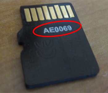
Q: Where do I find my digital map chip's serial number?
Your serial number is printed on the reverse of the microSD card. You will need to remove it from the SD adapter.
Q: I’m colour blind, can you make print maps with different colours?
We can. Please contact us directly.
Q: I don’t fish, can I still buy a map for my cottage?
Sure you can. While we initially designed our maps with anglers in mind, our feedback suggests that non-fishermen appreciate the printed maps for aesthetic reasons.